











An OTP will be sent to this number for verification

You may have a pre-approved offer
Enter required home loan amount
In summary
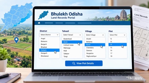
Explore Bhulekh Odisha Map- Access Bhunaksha Odisha Map for Land Records
Last updated: Sept 2026
Most first-time map viewers focus entirely on boundary lines and miss the land use classification shown alongside them. This 1 specific detail determines what a plot can legally be used for, independent of its shape or its total area.
- Core classifications shown: agricultural, homestead (Abadi), and other categories, spanning 5 to 6 common codes
- Where it appears: alongside the plot boundary on the Bhunaksha map display, often in an accompanying legend
- Why it matters: land use classification affects what construction or activity is legally permitted on a specific plot
- Mismatch risk: a plot's actual current use can differ from its recorded classification, particularly on older records
Verification step: cross-check the map's classification against the textual RoR record for the same plot number
Confirm the specific classification code for your plot, rather than assuming based on the plot's current visible use, since the two can genuinely differ.
Does a plot's classification always match its actual use?
Not necessarily, and this is a specific gap worth understanding directly. A plot's recorded land use classification on the Bhulekh Odisha map reflects what's officially recorded, which can lag behind an actual change in use that hasn't yet been formally updated in the record.
3 realistic scenarios explain why a classification mismatch can occur. The realistic scenarios behind a classification mismatch are:
- A plot converted from agricultural to residential use informally, without the formal conversion process being completed and reflected in records
- An older map record that predates a genuine, formal land use change that has since been properly updated elsewhere but not on this specific display
A data entry inconsistency between the textual RoR and the map's own classification display for the same plot
Treating the map's classification as automatically current, without cross-checking against the textual record or a direct local inquiry, risks relying on outdated information for a genuinely important decision.
Show more
Show less
What do the common land use classification codes actually mean?
| Classification | What it commonly indicates |
|---|---|
| Agricultural | Land recorded for farming or cultivation use |
| Homestead (Abadi) | Land recorded for residential or homestead use |
| Government/ Gochar | Government-owned or common grazing land |
| Forest | Land classified under forest department jurisdiction |
| Water body | Land recorded as a pond, tank, or similar water feature |
Homestead classification specifically is what a buyer planning residential construction needs to confirm, since building on land still classified as agricultural, without proper conversion, carries the same legal risk discussed for NA conversion in other states.
Show more
Show less
How do I verify a specific plot's classification correctly?
Four steps confirm a plot's genuine current classification beyond the map display alone.
- Note the classification code or category shown on the Bhulekh Odisha map for your specific plot.
- Cross-check this against the textual RoR record for the same plot number, confirming consistency between the two.
- Where discrepancy exists, or you plan construction, confirm current status directly with the local Tahasil office.
For agricultural land intended for residential use, confirm whether formal conversion has been completed and is reflected in current records.
Relying solely on the map's visual classification, without this cross-check, is a common gap for buyers unfamiliar with how Odisha's land classification system actually works in practice.
Show more
Show less
A worked example: catching a classification mismatch before construction
Consider Debasish, a 41-year-old shop owner in Cuttack with a household income of Rs. 1.1 lakh a month and a CIBIL Score of 746, planning construction on a plot he'd assumed was residential.
| Step | What Debasish found |
|---|---|
| Checked Bhulekh Odisha map | Classification showed agricultural, not homestead |
| Cross-checked RoR | Confirmed the same agricultural classification in the textual record |
| Contacted Tahasil office | Confirmed no formal conversion had been completed |
| Applied for conversion | Initiated the formal process before proceeding with construction plans |
Because Debasish checked the actual classification rather than assuming based on the area's general residential character, he avoided beginning construction on land not yet legally cleared for that specific use.
Show more
Show less
Home loan for professionals
Financing construction once classification is confirmed with Bajaj Finance
| Loan feature | Detail |
|---|---|
| Interest rate | From 7.25% p.a.*, subject to credit assessment |
| Loan amount | Up to Rs. 15 Crore* |
| Tenure | Up to 32 years |
Bajaj Finance verifies land use classification alongside standard title checks for any Odisha property offered as loan collateral. Approval timelines can extend where classification needs confirmation or formal conversion is pending, and this varies by Tahasil. Check your home loan eligibility once your plot's classification is confirmed.
Show more
Show less
Frequently Asked Questions
Understanding classification codes
Practical verification
Can I build a home on land still classified as agricultural if my neighbours have already done so?
Not without risk, since your neighbours' informal or completed conversion status doesn't apply to your own plot's specific record. Confirm your own plot's classification and conversion status independently, rather than assuming your situation matches a neighbouring plot simply because the general area around it happens to look genuinely residential today.
Why does my plot's classification show differently on the map than what my grandfather always called it?
Informal, long-standing family or local terminology for land doesn't always match the specific official classification recorded in government systems. Confirm the actual current classification through the official Bhulekh Odisha map and RoR record directly, rather than relying entirely on inherited family understanding of the land's actual, current, and official legal status.
Who do I contact if I believe my plot's classification is recorded incorrectly?
The local Tahasil office handles classification corrections and can guide you through the specific rectification process, which requires supporting documentation showing the plot's actual, genuine historical or current use, as a rule. This process takes real time, so initiate it well ahead of any planned construction or property transaction that depends on it.
Does land use classification affect property tax, or only construction permissions?
It can affect both, since classification often factors into property tax assessment alongside construction and land use permissions. Confirm with the relevant local authority how your specific plot's classification affects its applicable tax treatment, particularly if a recent, genuine conversion hasn't yet been reflected properly in your specific local tax records.
Home Loan in Different Cities

Home Loan in Mumbai

Home Loan in Ahmedabad

Home Loan in Bangalore

Home Loan in Chennai

Home Loan in Delhi

Home Loan in Hyderabad

Home Loan in Cochin

Home Loan in Noida

Home Loan in Pune
Home Loan for different budget
Check your pre-approved offer now
Our Calculators






What do our customers say about us
customers
Play Store rating
reviews
Amit Shiva
Reviewed on
Smooth and transparent home loan process. The interest rates were competitive, and documentation was minimal. The team guided me clearly at every step, making my first home purchase stress-free. Highly recommended for quick approvals.
Sandeep Kulkarni
Reviewed on
The loan disbursal was fast, and the customer support team was extremely patient with all my queries. Flexible EMIs helped me manage my monthly expenses easily. A great experience for salaried homebuyers.
Ritika Agarwal
Reviewed on
I had a great experience while transferring my existing home loan. The process was quick, and I saved significantly with the lower interest rate. Customer service was helpful throughout. Highly recommended for balance transfers.
Manoj Verghese
Reviewed on
Clear guidance, quick approval, and flexible repayment options made buying my new house easier than expected. The team handled everything professionally. Very satisfied and would definitely recommend their home loans
Find your nearest branch

More Articles




Watch our videos

Documents required to get a Bajaj Finserv Home Loan

Tips to increase your Home Loan eligibility
Things you need to know about pre-approved home loan

Things you need to know before applying for a Home Loan

How does Repo Rate affect your Home Loan

Download App
Now request money from your friends and family and make instant payments.

- Choose from personal, business, gold loans and more
- Pay utility bills, use UPI, get FASTag and more
- Buy over 1 million products on No Cost EMI
- Buy stocks, mutual funds and invest in FD
Disclaimer
1. Bajaj Finance Limited (“BFL”) is a Non-Banking Finance Company (NBFC) and Prepaid Payment Instrument Issuer offering financial services viz., loans, deposits, Bajaj Pay Wallet, Bajaj Pay UPI, bill payments and third-party wealth management products. The details mentioned in the respective product/ service document shall prevail in case of any inconsistency with respect to the information referring to BFL products and services on this page.
2. All other information, such as, the images, facts, statistics etc. (“information”) that are in addition to the details mentioned in the BFL’s product/ service document and which are being displayed on this page only depicts the summary of the information sourced from the public domain. The said information is neither owned by BFL nor it is to the exclusive knowledge of BFL. There may be inadvertent inaccuracies or typographical errors or delays in updating the said information. Hence, users are advised to independently exercise diligence by verifying complete information, including by consulting experts, if any. Users shall be the sole owner of the decision taken, if any, about suitability of the same.